The map of Rome is more than just a visual representation of Italy’s capital; it’s a window into over two millennia of history, culture, and civilization. From the ruins of ancient empires to Renaissance art treasures and modern-day districts, navigating Rome requires more than just a GPS signal. Whether you’re a tourist, a student of history, or a curious traveler, this detailed guide will walk you through everything you need to know about using a map of Rome effectively.
Why the Map of Rome Is Essential for Visitors
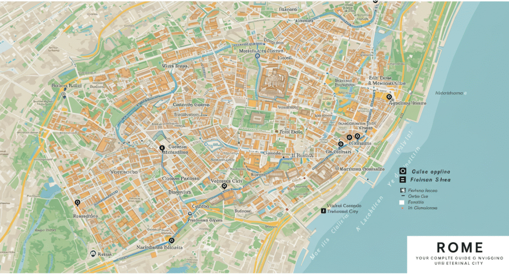
Rome isn’t a grid-like city that you can memorize in a day. The map of Rome includes winding alleys, hidden piazzas, and layers of history stacked upon each other. Understanding this complex structure is essential if you want to fully immerse yourself in the Eternal City. The city’s layout can be confusing for first-time visitors, making a good map invaluable.
Ancient Rome and Its Position on the Map of Rome
When viewing a map of Rome, it’s helpful to understand where Ancient Rome began. The historic heart lies around the Roman Forum, Palatine Hill, and the Colosseum. These landmarks form the core of ancient Roman civilization and are centrally located on any map of Rome.
-
Colosseum: Located in the southeast of the historic center.
-
Roman Forum: Just west of the Colosseum, between the Palatine and Capitoline Hills.
-
Palatine Hill: One of the seven hills and believed to be where Rome was founded.
These landmarks are usually marked prominently on most printed or digital maps.
Vatican City on the Map of Rome
Though technically a separate country, Vatican City is an essential part of any map of Rome. Nestled on the western side of the Tiber River, it’s one of the most visited locations on Earth.
-
St. Peter’s Basilica: Easily identifiable on any map of Rome due to its iconic dome.
-
Vatican Museums: Includes the Sistine Chapel and is located north of the basilica.
-
Vatican Gardens: Although not open to the public without a tour, they occupy a significant portion of Vatican City.
Because Vatican City is so compact, its entire layout can be studied using a single portion of the map .
Major Neighborhoods Highlighted on the Map of Rome
Rome is divided into many neighborhoods, or “rioni,” each with its own character and historical significance. Here are some key areas to note on any map of Rome:
1. Centro Storico (Historic Center)
-
Pantheon, Piazza Navona, and Campo de’ Fiori are the major attractions.
-
Ideal for walking and exploring on foot.
-
Densely packed area found at the center of the map of Rome.
2. Trastevere
-
Located across the Tiber River on the west side.
-
Known for cobbled streets, artisan shops, and nightlife.
-
Easily spotted on a map of Rome southwest of Vatican City.
3. Monti
-
Close to the Colosseum and Roman Forum.
-
Trendy cafes, art galleries, and local shops.
-
One of the oldest districts marked in the southeastern quadrant on the map of Rome.
4. Testaccio
-
South of the Aventine Hill.
-
Famous for traditional Roman cuisine and a lively food market.
-
Slightly off the main tourist path but clearly labeled on detailed maps .
Key Attractions You’ll Find on a Map of Rome
No map of Rome would be complete without its iconic landmarks. These sites are usually marked in bold or red on tourist maps and highlighted in star ratings on digital maps.
The Colosseum
As one of the most recognizable symbols of Rome, the Colosseum is often a reference point on the map of Rome.
Trevi Fountain
Northeast of the Pantheon, the Trevi Fountain is typically crowded but essential on any tourist’s map of Rome.
Spanish Steps
Located at Piazza di Spagna, the Spanish Steps connect the lower piazza with the Trinità dei Monti church above.
Piazza Venezia
This is a central traffic hub often marked by the massive white monument known as the Altar of the Fatherland.
Villa Borghese
One of the largest parks in Rome, it includes gardens, museums, and even a small lake. Look for it in the northeast section on your map.
Using a Digital Map for Modern Navigation
Today, digital tools like Google Maps, Rome2Rio, and Citymapper make navigating the map more convenient than ever. But even these apps require an understanding of local geography and transportation routes.
Benefits of a Digital Map of Rome:
-
Real-time public transport updates
-
GPS-guided walking routes
-
Pinpointing restaurants, restrooms, and ATMs
However, keep in mind that certain older or less digitally connected neighborhoods may not be accurately labeled, especially when using non-localized settings. A hybrid approach using both paper and digital maps of Rome is highly effective.
Rome’s Public Transportation
Understanding the transport layout is essential when using a map . While walking is ideal in many areas, Rome also has an efficient metro, tram, and bus network.
Metro Lines
-
Line A (Orange): Runs from northwest to southeast, stopping at Vatican City, Spanish Steps, and Termini.
-
Line B (Blue): Runs north to south, with stops at the Colosseum and Circus Maximus.
-
Line C (Green): Still expanding, mostly serves eastern neighborhoods.
Major Train Stations
-
Termini Station: Rome’s central hub, prominently featured on all maps.
-
Tiburtina Station: Second-largest, found in the northeast.
Tourist Maps vs. Historical Maps of Rome
There are different types of maps depending on your interests:
Tourist Maps
-
Focus on landmarks, public transport, and restaurants.
-
Usually free at hotels, airports, and tourism offices.
-
Simplified and easy to read.
Historical Maps of Rome
-
Show how Rome looked during specific eras (Ancient Rome, Renaissance, WWII).
-
Useful for scholars, researchers, and history buffs.
-
Available in museums or online archives.
Thematic Maps
-
Food maps for finding the best eateries.
-
Art maps focused on galleries and public art.
-
Religious maps of churches and sacred sites.
Choosing the right map of Rome enhances your travel or study experience immensely.
Walking Tours and the Importance of a Map of Rome
Many guided or self-guided walking tours rely heavily on a detailed map . Some popular walking tours include:
-
Ancient Rome Tour: Colosseum, Roman Forum, Palatine Hill
-
Baroque Rome Walk: Trevi Fountain, Spanish Steps, Piazza Navona
-
Christian Rome Tour: Vatican Museums, St. Peter’s Basilica, San Giovanni in Laterano
Having a map of Rome with clearly marked walking paths, rest stops, and restrooms adds comfort and confidence to your exploration.
Tips for Using a Map of Rome Effectively
-
Familiarize yourself with cardinal directions (north, south, east, west).
-
Identify key landmarks near your hotel or apartment.
-
Mark rest points like cafes, benches, or shaded areas.
-
Highlight safety zones, such as embassies or police stations.
-
Use layers in digital maps for terrain, satellite, or transit views.
With these strategies, your map of Rome becomes more than a navigational tool—it becomes your best travel companion.
Conclusion
Understanding and using a map opens up a city brimming with history, culture, and life. From ancient ruins and majestic churches to hidden trattorias and bustling piazzas, each corner of the Eternal City tells a story. With a detailed and accurate map of Rome in hand, you’re not just navigating streets—you’re tracing the footsteps of emperors, artists, and saints.
So whether you’re planning your first Roman holiday or you’re a seasoned traveler looking for deeper insight, let the map be your guide into the heart of one of the world’s most captivating cities.